Below is a copy of the application in 1750 for a licence to enclose three paths by Stephen Croft, the Lord of Stillington Manor.
Two of these paths cut across south side of Stillington Common. This is now arable farmland, though in 1749 it was pastureland held in common with the first footpath being access for those entitled to graze their cattle, and it carried on to come out near the Mill. Unfortunately it crossed the pasture close to the newly built Stillington Hall, no doubt spoiling the view. It was removed some 400 or so metres south. It is clearly marked on 19th Century maps.
The third road mentioned does still exist, though in a much reduced form, as an access road to the field which held the fish pond known as The Carr. This is where Laurence Sterne had his nasty accident, falling through the ice while he was skating!
It has often been called 'The boating lake' by locals as oral history recalls that the Croft family used it for boating. However, it is believed to be have been the manorial fishpond that was created from marshland during the Medieval period being remodelled for a more leisurely pursuits at a much later period.
An avenue of Elm trees marked a road that was described as 'carriage width' was used to access the lake. This road, now long vanished, was a remnant of the road described in the petition. The Elms sadly fell victim to Dutch Elm Disease in the 1970s and 1980s.
Until the early 1980s, when they were bulldozed flat, there were massive banks, in places some seven or eight feet high surrounding the area and there was an island that had stood to one side. Some traces of the banking, much eroded, remain in the woodland on the site.
On many 19th Century maps the Carr can be clearly seen, but it was drained in the 1940s and is now pasture for horses. Though the lake does re-emerge during periods of heavy rainfall!
The entirely new information the application reveals is that this particular road Croft wished to enclose crossed Stillington Common from the east to the west by a fairly easy route, possibly to join Wandell Balk opposite Moor Lane, and was used as a road to nearby Huby. It was a wide road, Seven yards (6.4 metres) is equivalent to an average two lane highway. So could accommodate wagons. This road is now under pasture and arable land.
Roseberry Lane, which lies south of The Carr, was probably its replacement. Not convenient for Stillington's villagers but directly opposite the entranceway to the drive Croft had made to lead up to Stillington Hall.
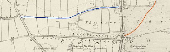
On the map above, dated 1856, The Carr can be seen, Roseberry Lane, (marked Roseberry Hill Lane) and a break in the trees to the north and east of where it enters York Road is the location of the entrance to the carriage way to Stillington Hall. The approximate route of the carriageway itself has been marked in red by Stillington Archive, bearing south-west as noted in the document.
The blue line indicates the road mentioned in the application as being 'on the south side of the said common along the north side of a fish-pond...'
At Old Malton, January 9, 1749-50.
George II to the Sheriff of York Greeting: —— We command you that by the oath of honest and lawful men you diligently inquire whether or no it be to the damage or prejudice of us or of any other if we should grant to Stephen Croft, Esq., licence to inclose a certain foot-way leading from a lane at the back of the south side of Stillington through certain pasture lands of the said Stephen Croft from the west to the east side of the Common of Stillington, in length six hundred yards or thereabouts, another footway leading from the aforesaid lane through another part of the said Stephen Croft's pasture land bearing south-west to the north side of the said common, being three hundred yards : also a common highway on the south side of the said common along the north side of a fishpond of the said Stephen Croft called the Carr, leading to a village called Huby, in length two hundred and thirty yards, in breadth seven yards, to hold the said footways and highway so inclosed to him and his heirs for ever, so that he do, in his own lands, set out two other footways and one other highway as convenient for passengers through the same, and if it will be to the damage &c., then to what damage, and that you return the inquisition thereof distinctly made without delay into our chancery.
Witness ourself at Westminster, September 15, 1749, King.
By Sir Dudley Ryder, Attorney General.
The execution of this writt appears in a certain inquisition hereunto annexed. John Bourchier, Esq., Sheriff; an inquisition, indented, taken at Stillington, October 5, 1749, before me.